Tuesday, 19 November 2013

Nepal: Trekking in the Himalaya

The view from the bus to Dhunche
To get to Langtang National Park, we had to take an eight-hour bus ride, much like the buses we experienced in Madagascar - old, broken-down, and cramped full of people. There were frequent stops to let people from the aisle head up on top of the roof of the bus. Some even jumped aboard and climbed up there while the bus was moving! We were thankful we had paid a bit more to book actual seats so we at least had a bit of room for ourselves and all our luggage. At one point, the radio playing Nepali and Indian music throughout the bus started blaring one of our favourites: Jai Ho, from Zumba! It definitely got me bouncing in my seat! :)


As more and more people came aboard we were squished between them and their belongings. People were friendly, though, and we tried to make room under seats for bags and such. One woman asked me if I would be willing to help her with her load - and gave me her baby to hold!


After eight hours, we arrived in the town of Dhunche, where we would start our trek. The first day proved to be a model for all of the other days - either straight up or straight down was the norm (often both in one day, over and over again). It was nothing short of gruelling. But the views were diverse and outstanding! Here are some of my favourites:

The view starting our hike from Dhunche
Hiking up, up, up!

It's autumn in Nepal now, too.

A typical Nepali mountain house.

Lunch at a teahouse on the trail.

The Prayer Flags hanging from a temple.

One of the nicer teahouses we stayed in.

We think this is a Mountain Eagle.

At a hilltop Buddhist stupa.


The Hindu sacred lake, Gosaikunda.

Nepal: Above the Top of the World


Nepal is a small country sandwiched between India, Bangladesh, and Tibet. It is famous for bordering the Himalaya mountain range - the tallest mountains in the world, and home to Mount Everest, THE tallest mountain in the world at 8848 m. (Click here to see my previous post on elevation to see Canada's tallest mountains). The most popular thing to do in Nepal is trek. There are many National Parks to visit, and you can hike for weeks along the border of the country! Many visitors go to Everest Base Camp, where people prepare for the treacherous climb up it (complete with ice climbing gear and oxygen tanks!), just to admire views of the famous mountain. Others opt for a view from the sky, which is what I did!

My family treated Mr. Elder and I to a Mountain Flight to see Everest from the air in honour of my birthday the week before. We were at the airport at 6:30 am, but had to wait hours for the fog to lift so we could leave. It was worth the wait, though! We had been in the air only minutes, and I was looking at Kathmandu from above when something caught my eye. There, looming above the city, above the horizon, above the clouds was the wall of giants, nothing like I'd ever seen, even coming from the Rocky Mountains!


The flight attendant handed out sheets with the panorama of mountains drawn on them so we could keep track. Then once we'd hit cruising altitude, guests were invited up into the cockpit for a full view, and I got to go first!


The pilot pointed out two twin peaks up ahead and told me that the one on the left was Everest - my first look! We then flew all the way out to it, turned around and flew back, so the other side of the plane got good views, too. It was a great birthday present!
Mount Everest is the peak on the left

Next, we're leaving to go on a nine-day trek through Langtang National Park where we'll hike from 1900 m up as high as 4610 m to go through a mountain pass, and down the other side. We'll stay at little 'teahouses' which are really basic cabins with bare beds and shared squat toilets. Check out my next entry to read all about it!


Thursday, 14 November 2013

Mauritius


After a quick four days in Réunion, we flew to Mauritius, an island that was owned by the British, but is now independent. It seemed to be in the middle in terms of quality of life - much better than Madagascar, where people are very poor, but not as high of a standard of living as Réunion.

In Mauritius, children learn French and a local Creole language at home, then learn English when they go to school, so communicating was very easy for us. The island makes its money mainly from sugarcane crops, tea plantations, and other agriculture. It had rolling hills and beautiful beaches (that are protected from coral reefs, so swimming is safe!).

The beach at Blue Bay

For my quick four days on the island, I ate lots of delicious food, which is a mix of Indian, Chinese, and Creole (so lots of chicken fried rice for me!), and they make use of the local deer and wild boar.

I relaxed at a beautiful beach called Blue Bay, which was on the south-east shore, and toured the sites of the South. Here were a few highlights:

Grand Bassin: A Sacred Hindu Lake

A giant statue depicting the Hindu lord Shiva

The waterfall in Chamarel

The giant tortoises in Chamarel's protected area

The Seven Coloured Earths of Chamarel

The beach at La Morne

La Reunion


Next up was a quick tour of two islands east of Madagascar: Réunion and Mauritius. Despite the close proximity of these three islands, they are all very different in culture and quality of life.

We visited Réunion first. Believe it or not, it's actually a part of France! We thought it would have more of an `island feel`but it definitely felt like Europe, with little cafes, people out jogging, and fancy cars everywhere. It was such a big change for us from our first three months that we experienced a bit of culture shock. Everything was extremely expensive and we didn't encounter the friendliest people.

During our quick four days here, we spent some time at the beach, but we didn't swim. Réunion is known for the high number of shark attacks it has. The island rises quickly out of the ocean and there is no coral reef to protect it, so it is not safe for swimming. Plus, it's very rocky and wavy!

I celebrated my birthday while we were here, and we wanted to make it special. As you can imagine, that's difficult to do when every day of our trip already feels like a new adventure. So, we made sure to do something I'd never done before: we climbed an active volcano!

Now, I'll point out first that this volcano is not dangerous to climb. Most of the time it lays dormant, its hot lava bubbling below the earth. When it does erupt, it's not explosive, meaning the lava comes up over the side and flows down to the ocean. It does not spew lava up into the air. The third thing that makes it safe to climb is that there are volcanologists who constantly monitor the volcano's activity, and we were told they would alert climbers if they detected anything.


The volcano is called Piton de la Fournaise (remember they speak French in Réunion), and it's the island's second highest peak. It is very popular to climb, so we definitely were not alone. The hike was difficult, 15 Km in total, taking us down 580 steps, across a flat plain of hardened lava, and up and around the side of the volcano to a spot at the mouth that's safe to stand on. The sun was hot, as was the heat radiating off the blackened ground. But the views were incredible!

At the top we were a little disappointed that there was no red lava on the inside, but I was proud of doing the climb and excited to have tried something new!

Looking into the mouth of the volcano!

Tuesday, 22 October 2013

Madagascar: Finishing a Fantastic Trip

The final leg of my time in Madagascar took me all the way to the West Coast. I first passed through Isalo, a hot desert town, where I hiked through a river-cut canyon and found one last lemur species, the Verreaux Sifaka. You might've thought I'd be sick of seeing lemurs by this point, but each time it was just as exciting, and this viewing may have been the most exciting of all. Even though Isalo National Park is the most visited out of all of Madagascar, Mr Elder, our guide, and I were the only ones on the trail when these two charming lemurs decided to take the same path as us. Our videocamera was unfortunately out of battery life, so a series of pictures is all we have to communicate the adorable way they bounced along the trail on two legs like humans!


In Isalo we also had the opportunity to visit a sapphire mine, which was really interesting! They dig straight down searching for round river rocks, an indication that sapphires might be present. If any are discovered in a test dig, they will continue the open-pit mine, pumping underground water out, while workers carry heavy bags of dirt up to the top to be sifted. I learned that sapphires actually come in all colours, and rubies are actually red sapphires and emeralds are green ones! The most traditional deep blue colour is the most rare, and therefore, most expensive to buy.


Next, we arrived at the port town Tulear where we watched sunset views over the Mozambique Channel. We had to take a boat transfer to get to our last destination, Anakao, a beach town just south of Tulear. We relaxed and walked the beach, eating fresh fish for lunch and dinner.


Then we flew back to Antananarivo for a night so that we could catch our flight onwards to the French island Reunion.

All in all, I have fabulous things to say about Madagascar! It is a country full of polite and friendly people who made this the most enjoyable country to visit so far on the trip for me. The landscape is incredibly diverse and beautiful, as you have likely seen from all of my photos. It was tough to choose from the hundreds we've taken because they are all so stunning! There's something for everyone from white-sand beaches with turquoise water, to dusty deserts with baobab trees, to hills, mountains and rock cliff faces.

Although expensive to get to due to its distance from us, it is incredibly cheap once you're here. We stayed in nicer hotels or private bungalows with great views for usually $20-$30 Canadian a night. That means, unfortunately, that the standard of living here is far below what we experience at home. Electricity and running water in homes is unlikely. As you read in earlier posts, many children do not attend school and sadly a good portion of the population is illiterate (unable to read). Adults and children alike work very hard to provide for themselves.

Two days after we leave, Madagascar is having a federal election. They have had years of instability in their government, so this could provide the opportunity for growth and change. I know that Mr. Elder and I will be watching to see how everything unfolds and we'll be hoping that it improves the lives of the Malagasy people. We'll find a charity to donate to that increases opportunities for education because it pained us both to see children working instead of attending school. They are a nation of wonderful people who I hope to see thrive and improve their quality of life. It is a good reminder to us to be thankful for the things we often take for granted!


Monday, 21 October 2013

Madagascar: Trekking to the Top

From Ambalavao, I had to take a 4x4 along poor roads to get into Namoly Valley, which is the gateway to the Andringitra National Park. The road was so terrible that our driver brought along planks of wood so that he could build one of the bridges for us to drive over! (Then, we had to pick up all the boards again after we were across). Along the drive I saw kids walking to and from school from their small villages. Our driver told me that some have to walk up to an hour each way to get to school! There are so many children and so few schools and teachers that children, even up to high school age, only go for a few hours a day! They excitedly raced behind our car when we drove by, knowing that tourists bring business to their towns.


The next morning, Mr. Elder and I, and two other Canadians we had met along the way, headed out to hike up the second-highest peak in Madagascar, Pic Boby. (The highest peak is in the North, close to Diego Suarez, and is not summitable). It sure looked like a long way away! The plan was to complete a 3-day trek as follows:

Day One - hike 12 km across the valley, up along the primary rainforest, across a plateau, and camp at the base of the summit
Day Two - start at 4am to hike to the peak for sunrise, then hike back down to camp for breakfast (7km total), then continue hiking across the plateau, up and over the mountain pass, and camp at a different site on the other side of the mountain range another 9.5km
Day Three - descend the rest of the range, hike through the valley, past small towns to get to our lodge (7.5km)

A long way to walk!

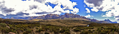
The first day of hiking wasn't too bad - a little steep in parts, and super hot, but the scenery was outstanding, and our little camp seemed cosy. We'd hiked 12 km in 5 hours, and reached the base camp of Pic Boby. We were thankful to have porters who carried our big bags, so that we only needed to take our day packs. They were heavy enough when filled with 3L of water each and snacks for the day!


We reached 2000m elevation! Still 662m to go!

It looks closer now!

Our Campsite

We cooked a simple dinner of rice and beans with chopped onions over a wood-burning fire. We anxiously watched a storm roll in, and were pelted with hail as we ate. The night was uncomfortable with huge winds blowing rain at us, making us feel even more cramped in our tiny tents. But when we got up at 4am, the stars were like nothing I had ever seen! We hit the trail with flashlights and headlamps in an attempt to be at the summit for sunrise. It took us a little longer than hoped, our tired legs complaining with each step of the steep trail, but we made it eventually!

Watching the sunrise as we hiked

At the summit!!!
Then it was back down to have a quick breakfast at the camp. We knew the itinerary for the day was tough - we'd already hiked 7km, plus the 12 from the day before, yet we still needed to hike up and over the mountain pass to make it to the second camp. But none of us had slept well, and the idea of another night exposed under the stormy skies had us wishing for a real bed. So we made the decision to change our plans. We were going to attempt to hike all the way to the lodge that day. That meant another 17km to go!

It started easy, as we walked along the stunning mountain pass, crossing creeks and passing bushes of wildflowers. Then with gritty determination we climbed straight up, knowing this was the last big ascent of the trip. We rewarded ourselves with a few handfuls of nuts and some candy at the top, then continued going. There was more than just the physical challenge ahead of us - we knew the other factor was daylight. The sun sets here at 5:30 pm, so we'd have to keep an eye on our stops to ensure they weren't longer than 10 minutes or so. We rested when we needed to, but basically continued trudging on.


The scenery was now quite different - boulders perched precariously on other stones and the bushes were scraggly. The climb down the other side was tough on our knees, but we were thankful it wasn't raining, as that would've made it slippery. We reached Camp 2, and were feeling motivated to finish. Only 7.5 km to go!

Cowboy Hat Rock!

When we crested the hill and saw the valley below, it brought both relief and discouragement. We could see our final destination, but it seemed impossible that we still needed to hike so far. The valley dipped far below us, then rose on the other side (reasonably gently, but to us, the idea of another incline was disheartening). It took another hour and a half, but we finally made it. We had hiked 36km in 34 hours!


You can image how great we all slept that night stretched out in big comfy beds, and although extremely sore, we were thrilled the next day to look out at the impressive views of the mountain range we'd just passed. We congratulated each other, not just on the physical achievement, but on the fact that we remained upbeat and positive through the whole trip, even when we felt we couldn't possibly finish it. Mr Elder said he'd been waiting for the perfect opportunity all trip, when we were both happy, and the location was beautiful and meaningful, to ask me something special. So overlooking our mountain pass, we got engaged! :) I guess when I come back to Calgary, I won't be Ms. Tamblyn anymore.